Laboratorio di Geologia Strutturale, Cartografia Digitale 3D e Geomatica

Prof. Associato SSD: Geo/03
Tel. Ufficio +39 0871 355 6416

SC: 04/A2 Geologia Strutturale, Geologia Stratigrafica, Sedimentologia e Paleontologia – SSD: GEO/03 Geologia Strutturale
SC: 08/A4 Geomatica – SSD: ICAR/06 Topografia e Cartografia
d.cirillo@unich.it | daniele.cirillo@unich.it
Tel. Ufficio +39 0871 355 6389

Rilevamento geologico digitale e modellazione 3D
Uso di software dedicati di Rilevamento Digitale per la raccolta di dati, immagini ed informazioni georeferenziate; Logging stratigrafico digitale; plottaggio automatico di strutture planari e lineari su proiezione stereografica; analisi strutturale in tempo reale.
Upload di dati da rilevamento digitale in progetti ArcGIS and MOVE-Petex.
Elaborazioni di carte e sezioni geologiche in ambiente ArcGIS 10.8 e MOVE v.2022
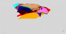
Elaborazione di modelli geologici 3D integrando tutti i dati disponibili (di superficie e di sottosuolo)

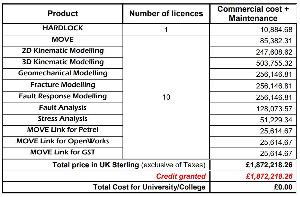
EDUCATIONAL INSTITUTION LICENCE AGREEMENT between Petroleum Experts Limited (PETEX Ltd.) and d’Annunzio University of Chieti-Pescara (Ud’A)
(contract Ref: Agr_ULA_UniChieti_19_05_01)
The PETEX Licensor has kindly donated to the DiSPUTer department (Ud'A), ten sets of the MOVE suite program with free software upgrades.
The program is licensed exclusively for teaching, tutorials, and non-commercial research, for relevant Master's and Ph.D. courses. The software will not be used for any commercial purposes, including commercially funded projects.
The Licensor has donated through a credit granted amounting to £ 1,872,218.26 and for this reason, the cost for the Disputer Department and d’Annunzio University of Chieti-Pescara is equal to zero.
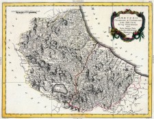
Le carte topografiche storiche (1986) della regione Abruzzo sono condivise in un archivio al seguente link: Cartografia Abruzzo
The historical topographic maps (1986) of the Abruzzo region are shared in a repository at the following link: Abruzzo Cartography
Computer
- N. 2 Desktop-PC
- 1 Desktop-PC: Intel Core i9-9940X processore 3,3 GHz 19,25 MB Cache intelligente – ROG Strix GeForce® RTX 2080 SUPER™ OC edition 8GB GDDR6 – Corsair Vengeance RGB PRO 128 GB (8x16 GB) DDR4 3000MHz C16 XMP 2.0 – Samsung MZ-76Q4T0 860 QVO SSD Interno da 4 TB, SATA, 2.5" – Samsung MZ-76E1T0B 860 EVO SSD Interno da 1 TB, SATA, 2.5" – Toshiba X300 4TB 4000GB Serial ATA III Hard Disk
- 1 Server PC (License Software)
- N. 2 Monitor Philips 27”
- N. 1 Hard Disk 8 TB
- N. 1 Hard Disk 16 TB
- N. 1 NAS QNAP TS-231K + 2 SEAGATE IRONWOLF 4TB INT. 3.5 Hard disk
Strumentazione
- N. 1 Drone DJI - Phantom 4 - Pro V.2
- N. 1 Drone DJI - Mavic 2 Pro
- N. 1 DJI Mavic 2 Fly More Kit
- N. 1 Batteria di volo intelligente DJI Mavic 2 Pro
- N. 1 Sistema GPS Emlid Reach RS2 GNSS/RTK L1,L2,L5
- N. 1 Antenne GPS per Drone Topodrone - TPD - L1/L2 RTK/PPK Upgrade Kit
- N. 1 Palina telescopica 2,40mt in fibra di carbonio ed alluminio, per GPS
- N. 1 Bipode, per supporto GPS
Software
- N. 10 Licenze Move suite 2020 software Petroleum Expert
- N. 1 Licenza Agisoft Metashape Professional
- N. 1 Licenza Software per analisi Post Processing Kinematic (PPK) - TDP - Toposetter v2.0.0.0
- N. 1 CloudCompare software
- N. 1 Abbonamento alla rete GPS SmartNet NRTK Full GNSS Unlimited
- N. 1 Licenze ESRI ArcMap/ArcGIS
- N. 1 Licenza QGIS
- N. 5 Licenze Kingdom Software
- N. 1 Licenza Corel Draw Graphic Suite 2020
- N. 1 Licenza Adobe Acrobat Pro
- N. 1 Licenza MatLab
- N. 1 Pacchetto Microsoft Office (Word, Excel, Power Point, Access…)